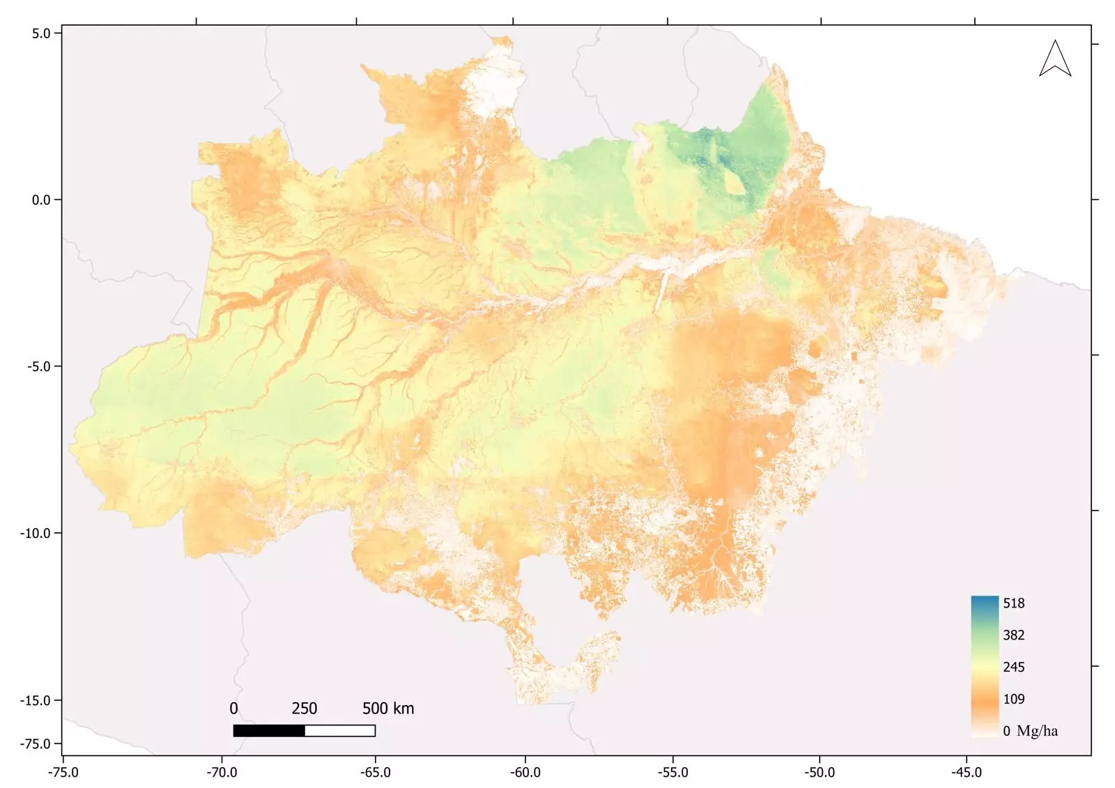
The release of a cutting-edge map showcasing the above-ground biomass in the Brazilian Amazon has brought a glimmer of hope in the face of the dire crisis engulfing the world’s largest contiguous tropical rainforest. This groundbreaking map, supported by the painstaking collaboration of research, technology, and data analysis, represents the most extensive survey of tropical forest biomass ever conducted. By employing airborne laser scanning, satellite imagery calibrated by field forest inventories, heavy-duty computer processing, and machine learning, the map offers unparalleled insights into the biomass distribution of this precious ecosystem.
Led by Jean Ometto, a senior researcher at Brazil’s National Space Research Institute (INPE), and a member of the steering committee for FAPESP’s Research Program on Global Climate Change (RPGCC), the arduous survey captured an awe-inspiring total of 3,600 square kilometers in transects. These transects, spanning all categories of vegetation within the Amazon, served as the foundation for the biomass estimation. The study revealed an average biomass of 174 metric tons per hectare, with a peak of 518 tons per hectare. Such comprehensive assessments, made possible by the novel integration of advanced technologies, shed light on the true extent of the rainforest’s biomass density.
The main survey harnessed the potential of airborne laser scanning, conducted during two consecutive campaigns in 2016-2017 and 2017-2018. A state-of-the-art LIDAR sensor mounted on a low-flying Cessna aircraft emitted eight laser pulses per square meter on average, tirelessly collecting data along each transect. The critical parameters of tree diameter at breast height, total height, and wood density were meticulously analyzed to estimate the above-ground biomass in kilograms. Furthermore, the findings from the 901 transects were synergized with data from instruments like PALSAR (Phased Array L-band Synthetic Aperture Radar) on the ALOS (Advanced Land Observing Satellite), MODIS (Moderate-Resolution Imaging Spectroradiometer), and precipitation data from TRMM (Tropical Rainfall Measuring Mission). This amalgamation of data sources allowed researchers to extrapolate the results for the entire Amazon region.
While the estimated above-ground biomass totaled a staggering 75 billion metric tons, it is crucial to acknowledge the ongoing challenges posed by deforestation. The period from 2019 to 2022 has witnessed significant deforestation, inevitably resulting in biomass loss and the release of carbon dioxide emissions. To better understand the extent of deforestation and its associated ecological impact, the map can be cross-referenced with data from INPE’s Deforestation Satellite Monitoring Service (PRODES). This invaluable resource provides stakeholders with a comprehensive overview of the changes occurring within the Amazon’s forest cover.
The creation of the map was not merely an exercise in static representation but a means to establish a dynamic time series. By conducting similar surveys in subsequent years, researchers will be able to ascertain whether the rainforest’s biomass is growing or declining. This knowledge is particularly vital in the face of mounting concerns about the Amazon’s precarious state. With the looming possibility of a tipping point, after which the rainforest ceases to act as a carbon sink and becomes a net emitter of carbon, and the degradation of its biomass into different forest structures, the map plays an instrumental role in supporting decisions related to planning, conservation, and sustainable management of this irreplaceable ecosystem.
Beyond the groundbreaking insights into the Amazon’s biomass distribution, the surveys have also unveiled intriguing archaeological discoveries. Pre-Columbian geoglyphs provide evidence of the rainforest’s relatively dense population in ancient times, opening up new avenues for studying the historical human-environment relationship. Additionally, the surveys confirmed the presence of the tallest tree in the forest, the majestic Dinizia excelsa, known locally as “Angelim vermelho,” which towers with its 88.5-meter canopy above the forest floor. These remarkable findings add further layers of complexity to our understanding of the Amazon rainforest.
The publication of the map showcasing the above-ground biomass in the Brazilian Amazon marks a significant milestone in comprehending the intricacies of this awe-inspiring ecosystem. By harnessing the power of advanced technologies and robust data analysis, the survey has provided researchers and decision-makers with invaluable knowledge crucial for the preservation and sustainable management of the Amazon rainforest.


Leave a Reply