The rapid advancement of technology has ushered in a new era of unmanned aerial vehicles (UAVs), commonly referred to as drones. These autonomous aircraft are beginning to reshape how we observe, monitor, and map environments. With their ability to collect vast amounts of data from previously inaccessible areas, UAVs have found a niche in various fields, from disaster management to urban planning. Researchers at Sun Yat-sen University and Hong Kong University of Science and Technology have made significant strides in this area with the introduction of SOAR, a cutting-edge system for environmental exploration and mapping. This groundbreaking system aims to enhance the efficiency of 3D reconstruction, a task that is becoming increasingly vital in an age characterized by rapid urbanization and technological innovation.
Despite the impressive capabilities of existing UAV systems, significant challenges persist. Techniques for 3D reconstruction generally fall into two categories. Model-based methods often prove cumbersome and expensive, relying heavily on pre-existing knowledge that can become outdated. On the other hand, model-free approaches allow for more flexibility by exploring and capturing data concurrently, but they struggle under the weight of local constraints that can limit their effectiveness. The researchers sought to eliminate the drawbacks associated with these categories by leveraging their strengths in a cohesive manner, ultimately promoting more efficient mapping efforts.
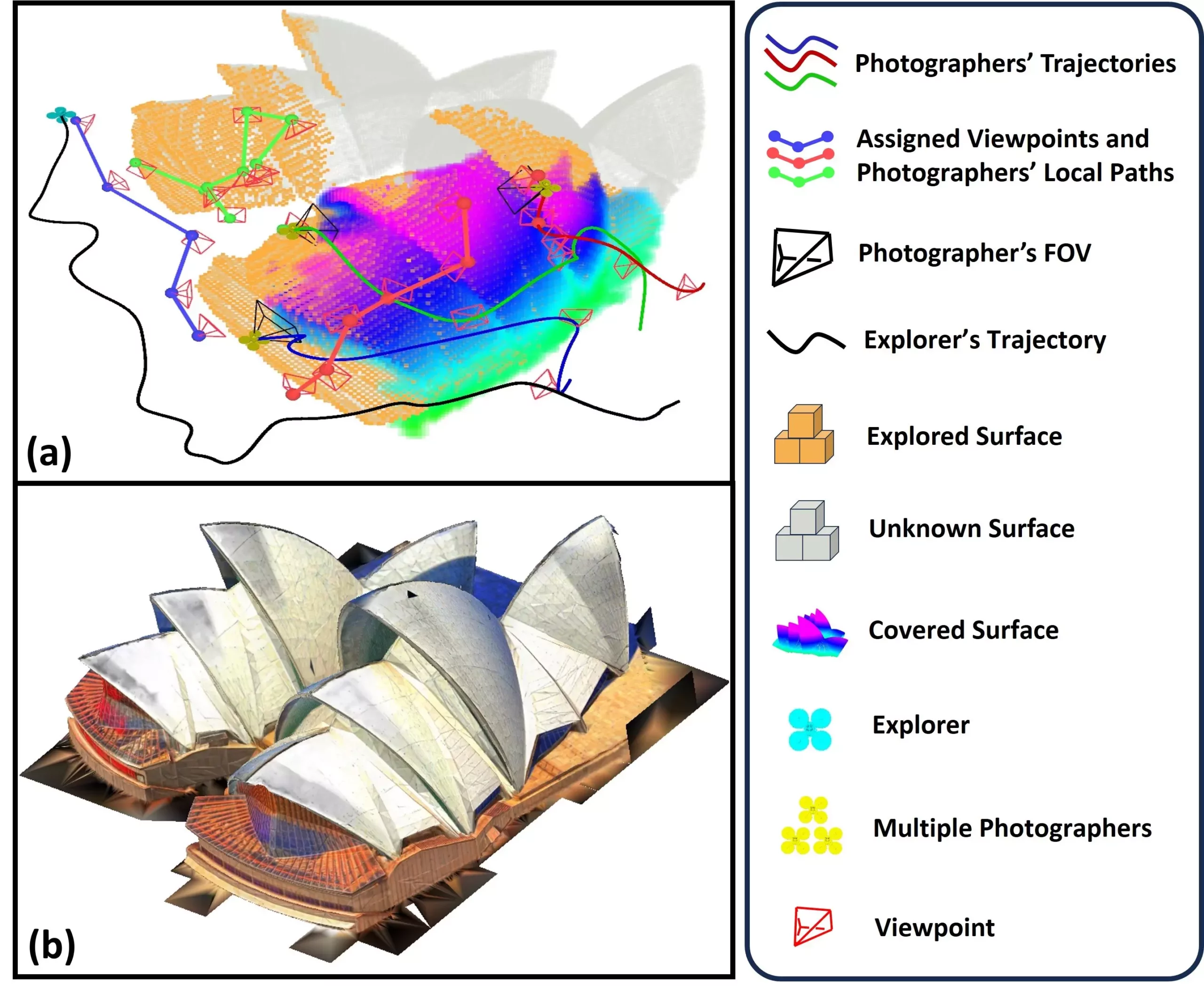
SOAR’s architecture is based on a heterogeneous multi-UAV system, designed to optimize the collection of environmental data. A defining feature of SOAR is its ability to operate both LiDAR (Light Detection and Ranging) technology and camera equipment simultaneously. The UAVs are divided into two roles: the “explorer,” which employs LiDAR for rapid mapping of the environment, and the “photographers,” that capture high-resolution images of designated viewpoints. This division of labor is critical in ensuring that the system efficiently gathers comprehensive data for 3D reconstruction.
With a novel incremental viewpoint generation approach, SOAR adapts to environmental dynamics in real-time. This allows it to optimize path planning and ensure sufficient data gathering coverage, enhancing its overall effectiveness. The researchers have implemented a task allocation strategy, utilizing the Consistent-MDMTSP method, to balance workloads among the UAVs while maintaining task consistency. This strategic organization allows each drone to contribute optimally to the reconstruction process while reducing unnecessary movements and delays.
The effectiveness of SOAR was rigorously tested through simulations, yielding promising results that positioned it ahead of contemporary methods in the field. By employing an innovative framework that integrates multiple algorithms designed for incremental processing, SOAR achieves a delicate balance between real-time planning capabilities and overall operational efficiency. This capability is crucial in scenarios where conditions frequently change and require adaptable drone operations.
The system’s performance in these simulations demonstrates its ability to create textured 3D models from collected data, showcasing the potential of SOAR to redefine conventional practices in 3D mapping and reconstruction.
SOAR’s implications extend across various fields. Its potential applications range from detailed urban mapping for city planning to cultural heritage conservation, allowing historians to digitally preserve valuable artifacts. One particularly encouraging prospect is the system’s use in disaster response scenarios, where rapid assessment of affected areas could facilitate timely rescue and recovery operations.
In the construction and infrastructure sectors, SOAR could serve as an invaluable tool for monitoring project sites, providing real-time, high-resolution visualizations that enhance decision-making processes. Furthermore, gaming developers could harness its capabilities to design immersive, realistic environments inspired by actual landscapes.
Looking ahead, the researchers express enthusiasm for ongoing advancements. Plans include refining task allocation strategies and incorporating prediction models that anticipate environmental structures, thus accelerating the mapping process. Adaptation to real-world conditions is another priority, requiring improvements to handle localization errors and communication challenges experienced during operation.
As the field of UAV technology continues to evolve, initiatives like SOAR represent a significant leap toward revolutionizing how we understand and represent our environments. Through continuous innovation and research, the aim is to bridge the existing gaps between simulation and active deployment, ensuring that these powerful tools realize their full potential in a variety of applications. With further enhancements, the SOAR system stands poised to transform the landscape of aerial mapping, paving the way for a more data-rich and comprehensively understood world.
Leave a Reply