As wildfires continue to become a pressing issue globally, those tasked with containing them often find themselves in precarious situations. Firefighters and disaster responders must act swiftly and decisively to ensure their safety when flames threaten to envelop their position. Traditionally, their decision-making is heavily reliant on experience and basic geographical data, often utilizing pre-determined escape routes under the assumption of a time estimate offered by their crew leader. However, the burning reality of unpredictable wildfires often leaves these professionals grappling with suboptimal evacuation routes that may increase their risk in high-stakes situations.
Current evacuation models primarily consider landscape steepness when assessing travel times, frequently ignoring other factors that contribute to the complexity of traversing challenging terrains. While a steep hill might present a steep ascent, it may still be quicker to traverse than navigating a boulder-strewn path or thick brush. This oversimplification leads to a significant underestimation of actual travel times, hindering emergency response and posing serious risks to safety. Recognizing this gap, researchers at the University of Utah have developed a groundbreaking model called Simulating Travel Rates in Diverse Environments (STRIDE), created to tackle these limitations head-on.
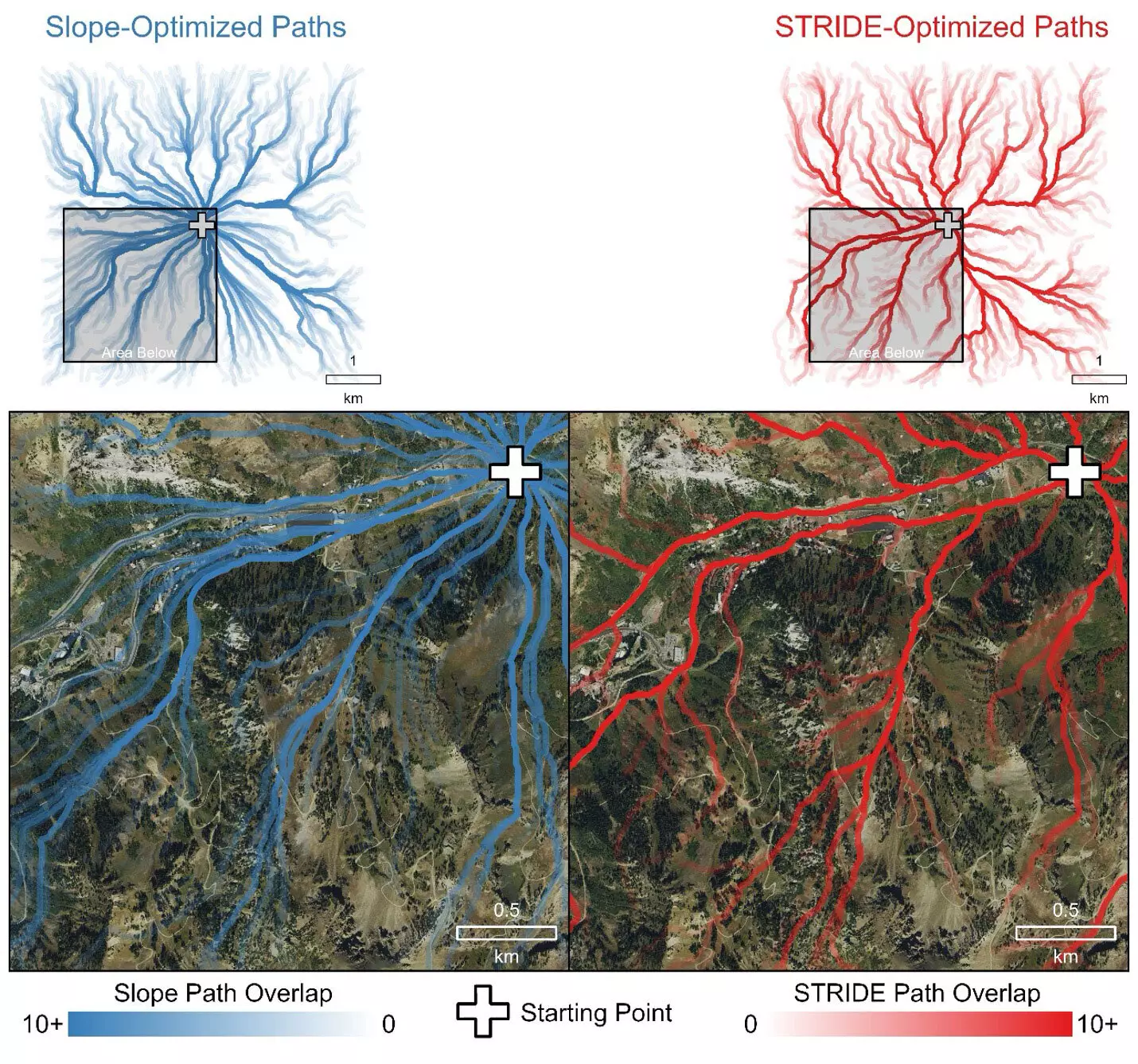
STRIDE represents a monumental leap in the methodology used to predict travel times in uneven and complex landscapes. By integrating data regarding ground roughness and vegetation density alongside slope steepness, the model offers an all-encompassing approach to estimating walking speeds across diverse environments. As lead author Mickey Campbell asserts, understanding mobility during wildfires can make a life-or-death difference, reflecting the urgent need for a robust tool that can provide accurate travel-time predictions.
Researchers employed advanced airborne Light Detection and Ranging (LiDAR) technology to gather viable data from varied terrains. This technique involves using laser pulses to create intricate, three-dimensional maps of landscapes, capable of capturing minute details. In doing so, STRIDE can identify the least resistant paths available—those that a human would instinctively choose based on their surroundings.
The researchers’ commitment to accuracy involved rigorous field trials, where volunteers traversed 100-meter transects in environments characterized by distinct vegetation and topographical challenges. By collecting travel time data, the team fine-tuned their predictions, thus ensuring the model could accommodate the vast variability in human mobility and outdoor conditions. These extensive tests ranged from urban to rugged mountainous locations, contributing to STRIDE’s versatility.
Performance evaluations also demonstrated that STRIDE consistently outperformed traditional slope-only models, which often failed to recognize established paths, roads, and the nuances of navigating dense vegetation or uneven surfaces. Such distinctions are crucial, as choosing an intuitive route can significantly expedite evacuation times.
Although initially designed with firefighter safety in mind, STRIDE extends its relevance to numerous fields, including disaster response, outdoor recreation planning, and even archaeological pursuits. The model’s flexibility allows it to inform any discipline that needs to assess pedestrian mobility in a variety of terrains, reinforcing the importance of considering multiple environmental factors in decision-making processes.
Furthermore, the researchers have made STRIDE publicly available, allowing other professionals or enthusiasts equipped with LiDAR data to apply the model in their own work. This accessibility not only encourages a communal effort towards improving safety in the face of disasters but also promotes best practices in emergency management.
As wildfires become increasingly unpredictable, the need for more sophisticated models like STRIDE grows ever more pressing. By considering multiple elements that impact travel time, this innovative model can play a vital role in enhancing the safety of those navigating hazardous environments. Whether for firefighting, search and rescue missions, or outdoor exploration, STRIDE offers the potential for real-world applications that are both scalable and impactful. By fostering a better understanding of how terrain complexity affects mobility, STRIDE paves the way for improved safety protocols and evacuations, saving lives in an increasingly uncertain world.


Leave a Reply