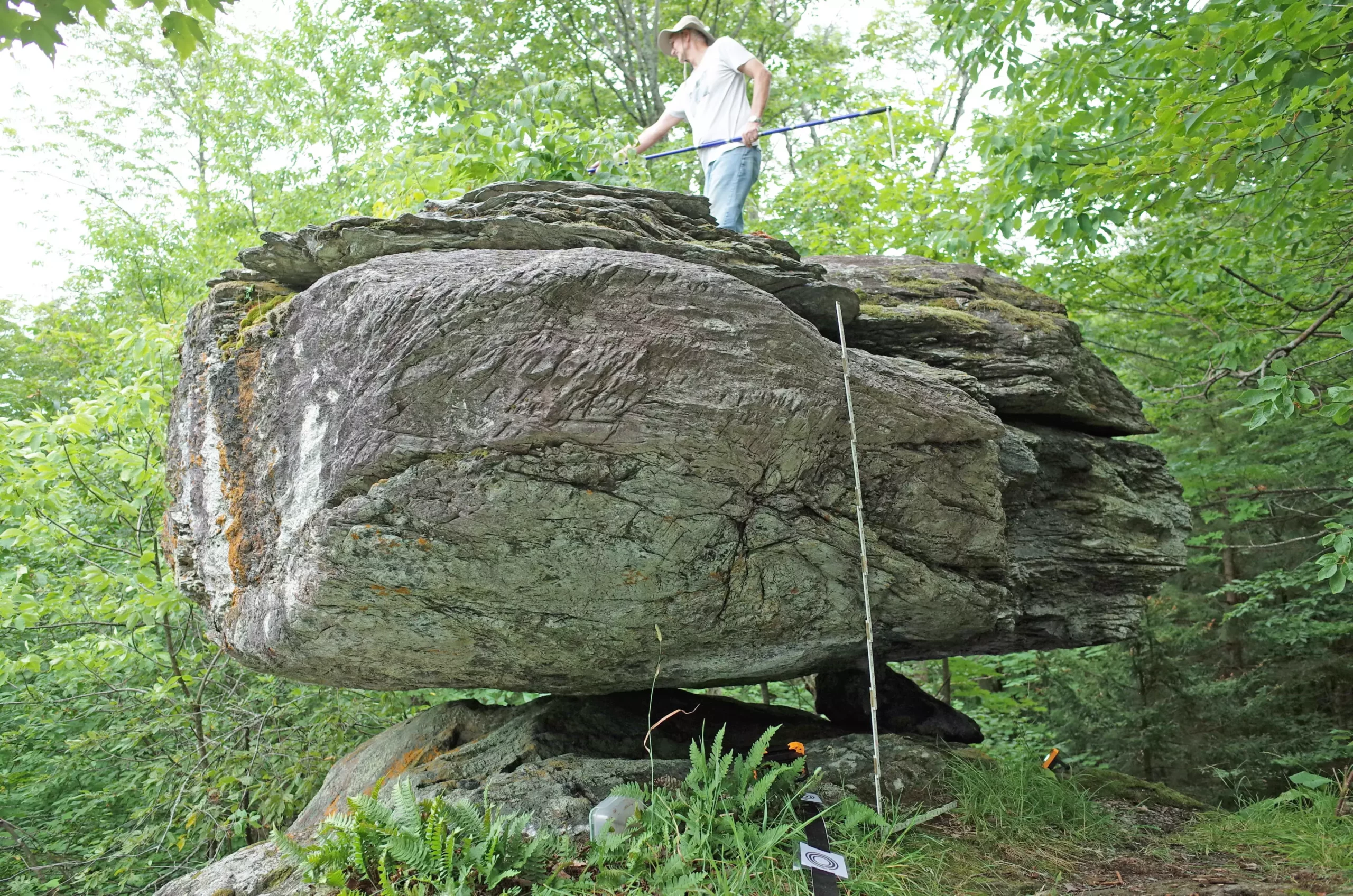
In the realm of seismic geology, there exists an innovative approach involving the analysis of Precariously Balanced Rocks (PBRs) to gauge the seismic hazards of specific regions. This intriguing method employs the balancing act of large boulders, particularly in areas rich with glacial history like northern New York and Vermont, to provide insights into the maximum potential shaking intensity caused by earthquakes. By examining the precarious positions of these rocks, scientists can infer the likelihood and historic levels of seismic activity in the area, offering vital data that can augment existing seismic hazard models.
The primary focus of researchers is to determine the stability of these PBRs and what conditions would lead to their dislodgement. Through meticulous examination, scientists can discern the minimal amount of shaking required to disturb these rocks. By studying five specific PBRs in northern New York and Vermont, researchers have marked a significant stride in understanding earthquake potential in the region. They investigate not only the physical fragility of these rocks but also their age, as older formations indicate periods of seismic inactivity or activity, allowing a historical overview of earth movements over potentially millennia.
The research findings correlate with the U.S. Geological Survey’s 2023 National Seismic Hazard Model, suggesting that the average seismic activity predictions align with evidence garnered from the PBRs. However, the interesting outlier is the PBR located at Blue Ridge Road in New York, which hinted at a potential reduction in seismic hazard, thereby challenging existing assumptions about earthquake intensity in that locality.
The boulders analyzed in this study are identified as glacial erratics—massive rocks transported and deposited by advancing glaciers thousands of years ago. These boulders now find themselves perched on pedestals, providing a testament to the geological history of the region. The last significant glacial retreat in New York and Vermont occurred between 15,000 and 13,000 years ago, suggesting that the PBRs are remnants of this dynamic geological past.
Understanding the characteristics of these glacial erratics is crucial for interpreting seismic hazards. The rugged terrain of the area posed challenges for researchers attempting to identify these fragile formations; however, local expertise played an instrumental role in facilitating the study. Collaboration with local hiking enthusiasts and the use of specialized hiking guides were critical in unearthing the locations of these elusive PBRs.
A notable outcome of this study has been the development of a detailed map indicating the proximity at which potential earthquake sources could exist without disturbing these PBRs. This mapping exercise is pivotal for defining active fault lines in the area and understanding their implications for future seismic events. It builds upon previous research that utilized geological features in other parts of the Eastern U.S., such as the New Madrid and Virginia seismic zones, but additionally introduces a unique perspective by leveraging the local geological features of the northeastern region.
The Broader Implications of PBR Research
The research conducted by Devin McPhillips and Thomas Pratt not only contributes to a localized understanding of seismic risk but also aligns with and supports broader findings within the field of seismology. Historical seismic events in the vicinity—such as the magnitude 5.7 earthquake in Massena in 1944 and others—underscore the necessity for ongoing research to understand the dynamic nature of the earth beneath our feet. This continuous exploration emphasizes that, while the region may not be classically considered a seismic hotspot, it holds unique geological characteristics that warrant further investigation.
As the understanding of seismic hazards in the eastern United States develops, so too does the potential for enhancing safety measures and preparedness tactics for communities at risk. McPhillips’ enthusiasm for the project and the continued search for more PBRs reflects a commitment to deepening this knowledge base, fostering a robust foundation for future seismic risk assessments and potentially lifesaving interventions.
The research on precariously balanced rocks in northern New York and Vermont signifies a promising frontier in the study of earthquake hazards. By bridging historical geological data with contemporary seismic models, this study illuminates the interactive effects of past glacial activity and ongoing geological processes. As seismologists seek to expand their understanding of this field, the insights garnered from the analysis of PBRs represent just the beginning of a rapidly maturing area of research that promises to inform both academia and public safety initiatives in the face of inevitable seismic activity.


Leave a Reply