Nitrogen dioxide (NO₂) stands out as a significant air pollutant with dire ramifications for public health, environmental integrity, and climate stability. This compound, a product of both human activity and natural phenomena, permeates our atmosphere primarily through emissions from combustion processes, including vehicles and power generation facilities. Compounding its dangers, nitrogen dioxide significantly contributes to smog formation—a phenomenon with visible air quality impacts that can hinder respiratory health, particularly among vulnerable populations. Understanding and monitoring its sources have become paramount.
For decades, advancements in satellite technology have enhanced our capacity to measure atmospheric pollutants. While earlier satellite systems, such as the Copernicus Sentinel-5P, provided valuable data on nitrogen dioxide concentrations, their broad resolution often obscured the pinpointing of specific pollution sources. This limitation left a frustrating gap in data quality, especially concerning localized emission concerns from power plants and industrial sites. Recent research, however, marks a notable evolution in this arena, leveraging Copernicus Sentinel-2 imagery to isolate and analyze nitrogen dioxide plumes with unprecedented precision.
The ability to utilize Sentinel-2, primarily designed for terrestrial monitoring, for atmospheric studies underscores the innovative potential residing in our satellite fleet. While traditionally directed toward land cover and vegetative assessments, researchers have recognized that the sensor’s high spatial resolution can aptly reveal air quality irregularities, particularly nitrogen dioxide emissions.
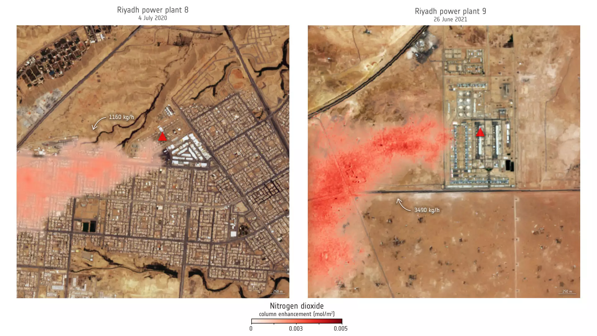
A recent study published in the Proceedings of the National Academy of Sciences showcases a breakthrough in this monitoring endeavor, utilizing both Sentinel-2 and U.S. Landsat satellites to trace emissions from specific power plants in Saudi Arabia and the United States. By honing in on the blue and ultrablue spectral bands, scientists successfully mapped NO₂ plumes from facilities like power plants in Riyadh and Wyoming, elucidating emission rates and seasonal variations over time. Notably, one significant finding emerged from Riyadh’s power plant, which demonstrated pronounced summer peaks in emissions correlated with increased air conditioning usage—a stark reminder of how human behavior interacts with environmental pollutants.
Daniel Varon, the lead researcher, emphasized the transforming potential of this capability, articulating the utility of pairing high-resolution images with environmental management efforts. The newfound ability to categorize pollution sources distinctly allows for effective urban planning and more rigorous regulatory standards, potentially safeguarding public health and enhancing air quality.
Challenges Ahead: Navigating Complex Terrain
Despite these advancements, satellite-based monitoring of nitrogen dioxide is fraught with challenges. Varon acknowledged the performance variations over diverse landscapes. Bright, uniform surfaces yield the most accurate readings, while complex terrains or darker regions may impede clear observation. This recognition reveals an important aspect of environmental monitoring; no tool is without limitations. Nonetheless, the capabilities presented through this research represent a noteworthy shift in our approach to pollution analysis.
The combination of historical data from Landsat satellites provides a rich context for understanding emission trends over time. As new satellite launches, such as Sentinel-2C, continue to enrich our imaging capabilities, the outlook for refining our air quality monitoring mechanisms looks optimistic.
The integration of satellite data into air quality management stimulates discussions on regulatory policy and environmental protection strategies. Accurate nitrogen dioxide tracking can inform legislative efforts to address air pollution proactively, ensuring that governments can implement targeted mitigation strategies where they are most needed. With this research paving the way, policymakers can benefit from deeper insights into dynamic pollution patterns.
As we continue to combat climate-related challenges, leveraging satellite technology to scrutinize pollutants in real time will be vital. Comprehensive data derived from this monitoring can empower decision-makers to craft effective public health policies and environmental regulations, marking a watershed moment in our collective response to air quality issues.
Harnessing these advanced satellite systems not only augments our understanding of atmospheric conditions but also holds the promise of transformative change in how we approach and mitigate pollution at a systemic level. The future of air quality monitoring is here—a future replete with potent data sources capable of driving impactful environmental change.
Leave a Reply