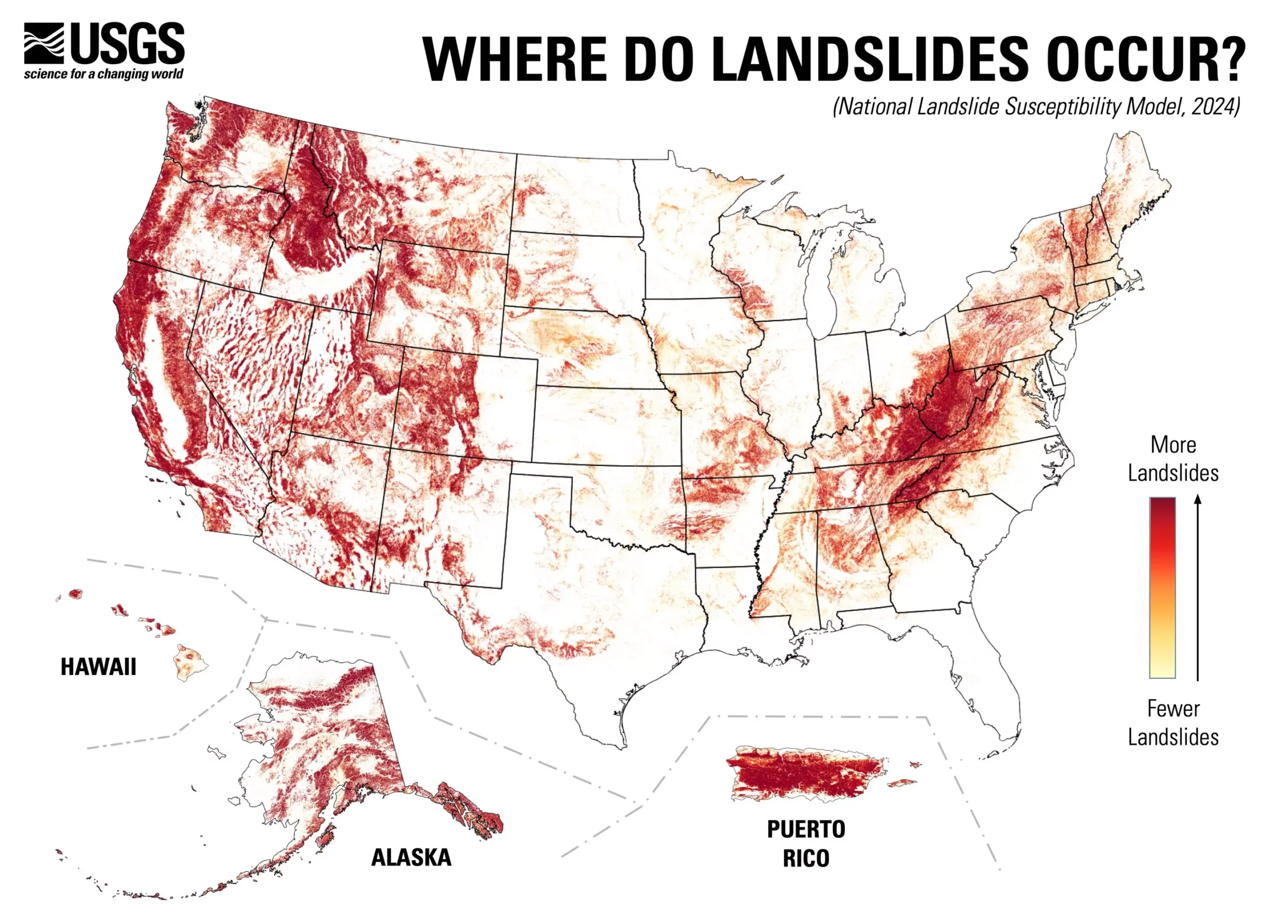
Landslides are natural disasters that can cause catastrophic damage, impacting infrastructure, ecosystems, and human lives. The recent release of a nationwide landslide susceptibility map by the U.S. Geological Survey (USGS) shines a light on the pervasive risk posed by these geological phenomena. According to the USGS, approximately 44% of the United States is susceptible to landslide activity. This groundbreaking map not only outlines high-risk zones but also highlights regions with minimal landslide hazards, offering a comprehensive tool to enhance public safety and disaster preparedness.
The USGS’s innovative approach to mapping landslide susceptibility marks a significant advancement in geological research and hazard preparedness. This map offers a county-by-county breakdown, enabling local planners and engineers to pinpoint areas needing attention. Ben Mirus, a USGS research geologist, emphasized the relevance of this tool by stating it directly addresses the challenging question of landslide prevalence across the nation. With this information readily available, communities are better positioned to implement risk-reduction strategies and improve land-use planning.
Creating this detailed susceptibility model involved an extensive dataset, including an inventory of nearly one million recorded landslides and high-resolution elevation data acquired through the USGS 3D Elevation Program. Utilizing advanced computational techniques, Mirus and his research team were able to produce a map that offers greater detail than previous continental and global assessments. This detailed methodology not only allows for a more accurate identification of vulnerable regions but also highlights areas where additional research and mapping are necessary to improve future hazard mitigation efforts.
Historically, localized mapping efforts focused predominantly on areas known for high landslide risks, often neglecting other regions where the potential for landslides exists but might have been underestimated. The new assessment fills this gap, providing a more holistic understanding of landslide vulnerability across diverse terrains in the U.S., including Alaska, Hawaii, and Puerto Rico. By expanding the focus to under-represented areas, planners and engineers can allocate resources more effectively, ensuring that even less recognized regions mitigate their geological risks.
The implications of this new susceptibility map extend beyond academic interest; they represent a proactive measure toward cultivating a hazard-ready nation. By assisting local governments and urban planners in prioritizing at-risk zones, this map serves as a beacon for communities to implement appropriate forward-looking policies. Areas identified as high-risk can thus become focal points for disaster preparedness initiatives, infrastructure reinforcements, and public education campaigns on safety protocols.
The USGS’s landslide susceptibility map is a vital contribution to understanding and mitigating natural hazards in the United States. By offering detailed insights into potential landslide activity, authorities can enhance their strategic planning, ultimately fostering a safer environment for all citizens. Such tools not only serve as resources for informed decision-making but also reflect a growing commitment to disaster preparedness and community resilience in the face of natural threats.


Leave a Reply