Situated along the Pacific Coast, the Cascadia subduction zone is an area marked by a complex history of seismic activity. Over the centuries, this region has experienced some of the most powerful earthquakes on record. One of the most significant seismic events occurred in 1700, resulting in widespread devastation and triggering tsunamis that reached as far as the shores of Japan. As urban areas continue to flourish along this perilous coastline, the impending question looms: when will the next “big one” strike? The challenge lies in accurately estimating the frequency of earthquakes and understanding their historical context through the geological record.
Scientists rely on various geological deposits to reconstruct the history of seismic activity, and one important type of deposit is known as turbidite. Turbidites are formed by underwater landslides, accumulating sediments on the seafloor after being disturbed by turbulent currents. Traditionally, researchers have identified turbidite layers as valuable evidence of past seismic events. However, a recent study from The University of Texas at Austin raises pertinent questions about the reliability of the turbidite record as a proxy for earthquake occurrences.
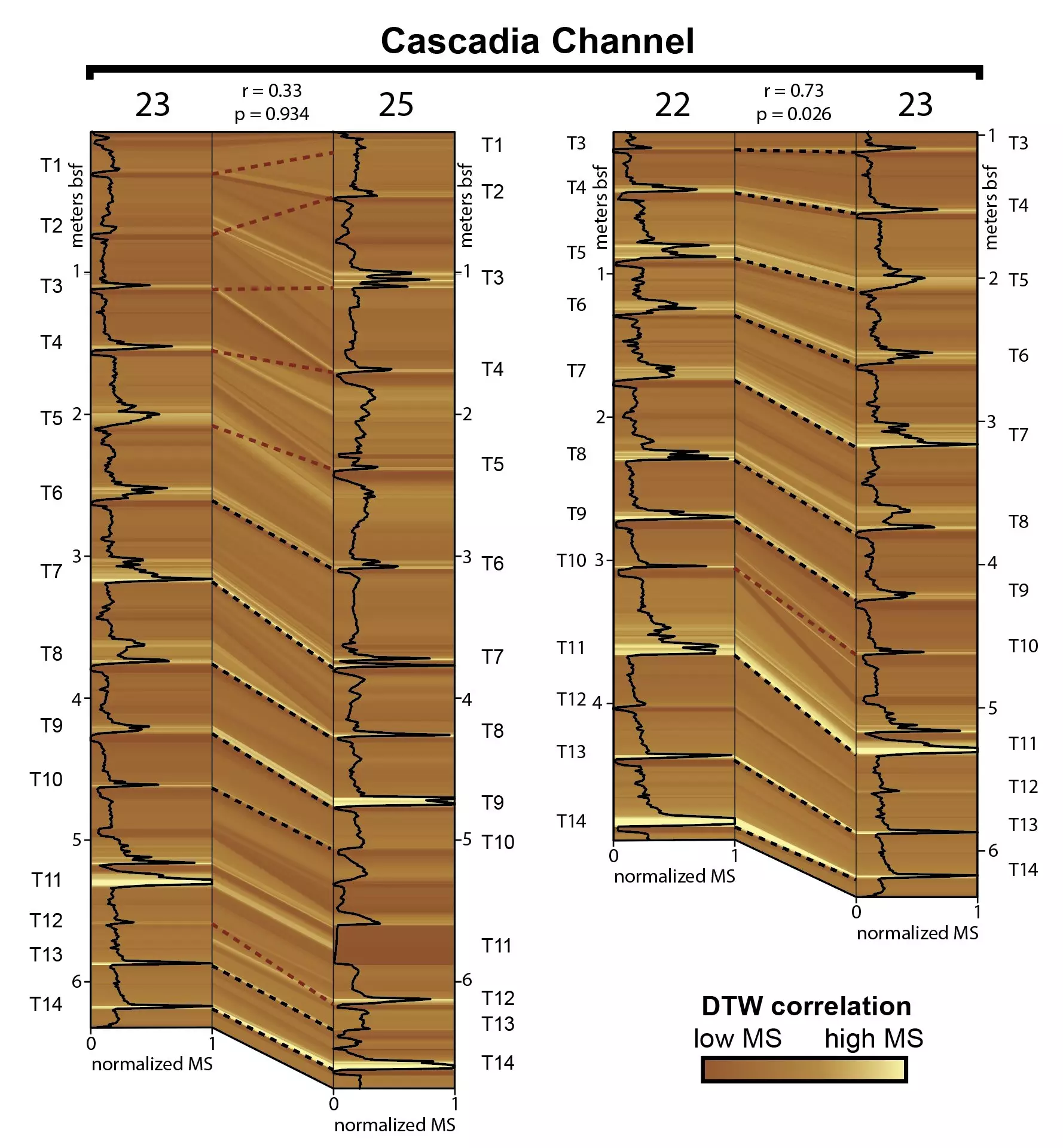
The research team employed an innovative algorithm to analyze turbidite layers dating back approximately 12,000 years, with an aim to assess how well these layers correlate with one another. What they discovered was surprising: the correlation between the samples was frequently no better than random chance. Such findings beg a reconsideration of how confidently scientists can link turbidite layers to specific earthquakes.
The implications of this study extend beyond academic curiosity; they resonate deeply with public safety and preparedness efforts. Joan Gomberg, a co-author of the study and research geophysicist at the U.S. Geological Survey, emphasized the need for caution among those relying on historical earthquake intervals derived from turbidites. While the researchers did not fundamentally alter the estimated earthquake frequency in the Cascadia region, thought to average every 500 years, they underscored the importance of enhancing research into turbidite layers and their interpretations.
Understanding the strengths and weaknesses in our geologic data can inform public policy, urban planning, and emergency preparedness strategies. Increased awareness and enhanced methodologies could diminish the impact of future seismic events on the densely populated areas along the Cascadia coastline.
At the core of this innovative research was the application of an advanced algorithm known as “dynamic time warping.” Traditionally used in fields like voice recognition and video processing, this algorithm evaluates time-varying data sets for similarities. The geoscientists adapted this methodology to analyze geological data, providing a more quantitative tool for interpreting turbidites. This groundbreaking approach could revolutionize how researchers correlate and understand historical data related to seismic activity.
The ability of dynamic time warping to identify underlying connections between seemingly unrelated samples gives geoscientists new avenues for exploration. The algorithm can detect shared characteristics among different turbidite layers, even when they exhibit significant variations due to geographical or depositional factors. However, with these advancements come challenges: applying this algorithm does not eliminate the need for careful human interpretation of data.
The study’s findings underscore an essential truth in the scientific community—this is an ongoing field of research that requires refinement and scrutiny. Co-author Jacob Covault acknowledged that while their research has provided a new method for interpreting ancient earthquake records, it is just a starting point. Further investigations will be required to ascertain the relationship between turbidite layers and past seismic events more definitively.
Going forward, the researchers urge caution in how past seismicity is framed. Geoscientists are tasked with interpreting results not only from newly developed algorithms but also by incorporating a broad range of qualitative geological observations. Combining these layers of evidence can potentially lead to a deeper understanding of subduction zone processes and their implications for future earthquake prediction.
The complexities of the Cascadia subduction zone highlight an urgent need for vigilance—both in research and public safety measures. While the natural dynamics of our planet can be unpredictable, equipping ourselves with the best possible data and methods can enhance our ability to prepare for future events. Addressing these seismic uncertainties is a crucial endeavor as we look to protect communities along the Pacific Northwest coast from the inevitable geological forces that will shape our landscape.


Leave a Reply