The urban landscape poses significant challenges for high-precision positioning systems, particularly those reliant on Global Navigation Satellite Systems (GNSS) like Real-Time Kinematic (RTK). The presence of tall buildings and dense urban infrastructure can obstruct satellite signals, causing interference that compromises the system’s accuracy and reliability. As cities continue to expand, the demand for precise positioning grows; however, traditional methods often fall short in these complex environments. Several technologies have been tested to alleviate these issues, including Wi-Fi and Bluetooth; nonetheless, they have not sufficiently fulfilled the requirements for high-precision navigation.
5G: A Game Changer for Navigation Technologies
The advent of 5G technology presents a remarkable opportunity to enhance GNSS-based positioning systems. With its impressive speed, wide bandwidth, and the ability to support a higher number of connected devices, 5G stands out as a promising solution to urban positioning challenges. By integrating this advanced communication technology with established satellite navigation systems, researchers are striving to overcome the limitations imposed by urban environments. The potential for improved signal strength and reliability paves the way for innovative applications that rely on precise location data.
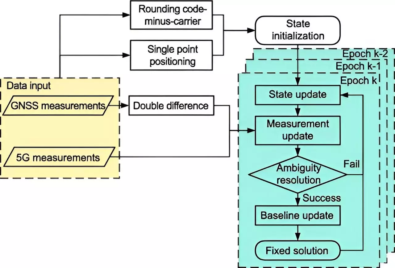
A team of researchers led by Dr. Tengfei Wang at Tsinghua University has made significant strides in this arena by developing a 5G-assisted BeiDou Navigation Satellite System (BDS) RTK positioning system. As detailed in their recent publication, the system intelligently combines 5G input with satellite navigation data using an extended Kalman filter and sophisticated ambiguity resolution methods. By leveraging additional information from 5G networks, the system enhances the quality of positioning within urban environments, showcasing its transformative potential for high-precision location tracking.
The effectiveness of the 5G-integrated BDS RTK system was evaluated using key performance indicators, such as the float solution and ambiguity dilution of precision (ADOP). Findings demonstrated substantial improvements in positioning accuracy, with spatial errors reduced by 48% during Full Ambiguity Resolution (FAR) mode and by approximately 18.8% in Partial Ambiguity Resolution (PAR) mode. Additionally, fixing rates experienced notable increases, illustrating the system’s enhanced ability to provide accurate positioning information even in signal-deficient urban canyons.
The integration of 5G technology into navigation systems is poised to revolutionize several sectors, including autonomous vehicles, public safety, and smart city initiatives. As urban centers become increasingly reliant on advanced positioning technologies, the scalable nature of the 5G-assisted BDS RTK system offers a reliable solution capable of addressing the unique challenges posed by urban environments. Upcoming research will focus on testing this innovative system across various real-world scenarios, continually refining its capabilities to ensure optimal performance.
A Step Forward in Urban Navigation
Ultimately, the collaboration between 5G technology and BDS RTK positioning stands as a beacon of hope for overcoming the longstanding limitations of urban navigation. By improving signal quality and satellite visibility, this innovative approach addresses critical positioning problems, paving the way for more accurate and dependable solutions. As we look to the future, the principles established in this research are set to lay a foundation for enhanced navigation systems that will adeptly serve the evolving needs of urban populations.


Leave a Reply